Alaska is the most seismically active state in the country, has had multiple "great" (Magnitude [M] 8 or larger) historic earthquakes, and has the potential to generate the largest earthquakes in the world. On average, Alaska has had one M 8+ earthquake every 13 years, one M 7–8 earthquake every two years, and six M 6–7 earthquakes per year (Alaska Seismic Hazard Safety Commission, 2012). Learn more about how earthquakes occur.
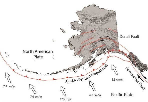
The southern edge of our state is an active tectonic plate boundary where the Pacific plate subducts (i.e., dives beneath) the North American plate along the great Alaska-Aleutian Megathrust. Our plate boundary comprises ~2,500 miles of the circum-Pacific "Ring of Fire" where ongoing subduction gives rise to arcs of active volcanoes and the largest earthquakes in the world. In Alaska, the Pacific plate, relative to the North American plate, moves at a rate of ~5.5+ cm/yr (~2.2+ in/yr). The Fairweather fault system in southeast Alaska (over 620 miles long) is the primary strike-slip structure that accommodates ongoing subduction. Plate convergence at the southern margin of the state drives distributed deformation on secondary faults over 400 miles northward into the continental interior. These secondary faults have also generated several significant historic earthquakes (such as the 200+ mile-long 2002 M 7.9 Denali fault rupture), and we are still discovering faults that are capable of large earthquake displacements.
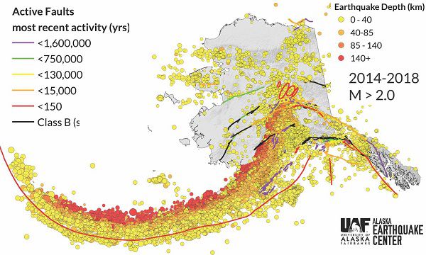
The image above shows all earthquakes greater than M 2.0 from 2014–2018. Cool colors represent deep earthquakes and warm colors represent shallow earthquakes. The general pattern of seismicity follows the Pacific plate as it subducts beneath Alaska. Because the production of earthquakes at our tectonic plate boundary is an ongoing process, it is imperative that Alaskans be prepared to protect their families and help their neighbors in the event of an emergency. DGGS' role is to study Alaska earthquake hazards that may affect the state and its people and distribute this information to the public.
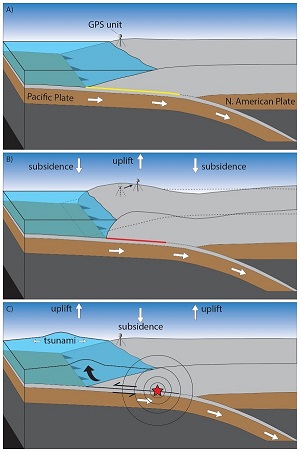
In some coastal regions of Alaska, where subduction zone earthquakes disturb large areas of the seafloor, communities are at risk of tsunami inundation. This 3-panel image shows a simplified representation of a tsunami-generating earthquake cycle on the Alaska-Aleutian Megathrust.
The sequence begins shortly after the last earthquake. As the two tectonic plates converge, friction between them causes coupling of the plates on locked patches of the fault (yellow line, part A). Because the plates are continuously moving, but are locked at the subduction zone, the stress imparted to the locked zone results in a build-up of energy and deformation in the surrounding plates—regions of uplift and subsidence (i.e., down-dropping) at the plate boundary (part B). When the stored energy overcomes the friction that is holding the plates together, the fault slips abruptly and creates an earthquake. This results in slip on the plate interface (sometimes many tens of meters), radiating seismic waves (shaking), and vertical seafloor displacement that can produce tsunamis (part C). When the plates come to rest after the earthquake, newly locked plate sections form and the cycle continues.
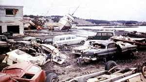
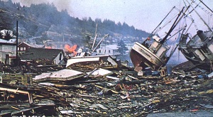
Kodiak after the 1964 tsunami.
On Good Friday, March 28, 1964, south-central Alaska was struck by the second-largest earthquake ever recorded. The M 9.2 earthquake ruptured a patch of the subduction zone that was ~500 miles long and 100–175 miles wide, producing vertical displacements over an area of about 110,039 square miles in south-central Alaska (Plafker, 1969). Widespread areas south of the Alaska coastline were raised up as much as 18 ft whereas other areas dropped as much as 6 ft. Portions of the overriding crust moved seaward as much as 50 feet in a matter of minutes.
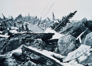
Turnagain Arm after the 1964 earthquake.
Shaking from this earthquake had widespread effects on Alaska and caused a total of $300 million (in 1964 dollars) in damage. There were a total of 131 fatalities associated with the earthquake, 122 of which were caused by tectonic and landslide-generated tsunamis. Some coastal communities, such as Kodiak and Chenega, were hit particularly hard.