Permafrost and periglacial hazards are caused by perennially-frozen soil, rock, or sediment—known as permafrost—and the landscape processes that result from extreme seasonal freezing and thawing.

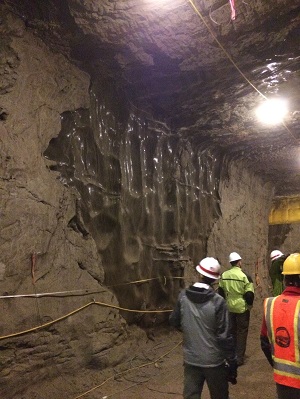
Massive ice wedge exposed in research tunnel into permafrost near Fairbanks, Alaska.
Permafrost, defined as ground with a temperature that remains at or below freezing (32° F or 0° C) for two or more consecutive years, provides a stable foundation for structures and infrastructure in cold-climate regions as long as the temperature of the frozen ground is well below freezing. A major hazard of warming and thawing permafrost is that ground ice degrades and the soil surface collapses. Fluctuations in temperature over the seasons also cause the ground to move as the upper layers freeze (ice lens formation) and thaw (loss of ice). Ice lenses may form under wet conditions as the ground freezes, especially in fine-grained soils such as silt or clay. Upon thawing, ground ice can cause an excess of liquid water that cannot be stored in the soil and needs to flow out of the soil as gravity consolidates the soil after thawing, leading to ground collapse.

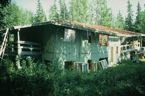
House damaged by thawing permafrost near Fairbanks, Alaska.
"Periglacial" refers to a cold-climate environment in which the effects of freezing and thawing drastically modify the ground surface. Types of modification include displacement of soil materials, migration of groundwater, and formation of unique landforms. Many periglacial regions are underlain by permafrost that strongly influences geomorphic processes acting in these parts of the world.
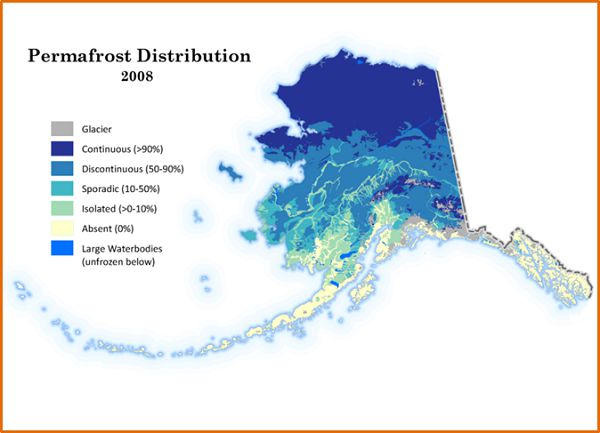
Permafrost is found beneath nearly 85 percent of Alaska. It is thickest and most extensive in arctic Alaska north of the Brooks Range, present virtually everywhere and extending as much as 2,000 feet below the surface of the Arctic Coastal Plain. Southward from the Brooks Range it becomes increasingly thinner and more discontinuous, broken by pockets of unfrozen ground known as taliks, until it becomes virtually absent in Southeast Alaska except for patches of high-elevation alpine permafrost.

Map showing 2008 permafrost distribution in Alaska. Percentages indicate how much of the ground surface is underlain by permafrost in each category. Source: Jorgenson and others, 2008.
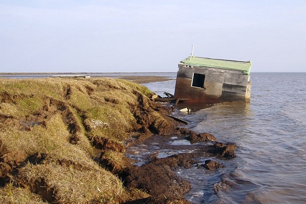
In the United States, the presence of widespread permafrost results in classes of geologic hazards that are largely unique to Alaska. Permafrost is structurally important to the soils of Alaska, and its thawing causes landslides, ground subsidence, and erosion as well as lake disappearances, new lake development, and saltwater encroachment into aquifers and surface waters. Usteq, from the Yup'ik word meaning "surface caves in," is a catastrophic form of permafrost thaw collapse that occurs when frozen ground disintegrates under the compounding influences of thawing permafrost, flooding, and erosion.

Usteq—a catastrophic form of permafrost thaw collapse—claimed this cabin at Elson Lagoon, Alaska. Photo credit: U.S. Geological Survey.
Permafrost is a part of almost all DGGS work involving surface materials and hydrology because it is found in many of our field areas and strongly influences surface processes, material characteristics, and landforms.